In the Odyssey, Homer wrote (Od.1.25-28):
Poseidon had gone to visit the Ethiopians worlds away,
Ethiopians off at the farthest limits of mankind,
A people split in two, one part where the Sungod sets
And part where the Sungod rises.
This passage describes the general progress of the Sun’s advancement throughout the day. This passage is significant because it shows us that even long before myths were being written down (c. eighth or seventh centuries BCE for Homer), geographical routes and astronomical information were being transmitted via oral tradition. It seems as though the ancient Greeks “named the directions of summer and winter Sunrise or Sunset, as distinct from the east and west directions in the spring and autumn seasons of equal days and nights” (1). Using the sun was key to determining geographical and chronological information in the Ancients’ daily lives and in travel.
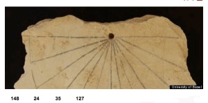
Above is an ancient Egyptian sundial (c. 13th century BCE). The fact that this 19th Dynasty sundial pre-dates Homer demonstrates the advancement of technologies in determining time. Dating to the 19th dynasty, this particular sundial was found on the floor of a workman’s hut, in the Valley of the Kings, where the pharaohs and nobles were buried during Egypt’s New Kingdom period (around 1550 B.C. to 1070 B.C.).
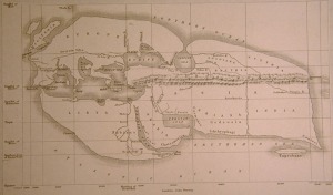
The world as known and documented by Erastothenes (276-195 BCE). Besides being most famously known as a Greek mathemetician, he was also a well-known historian, astronomer and geographer. He is considered to be the first person “to reduce the problem of terrestrial position-finding to a regular system,” which he based upon the gnomon (2).
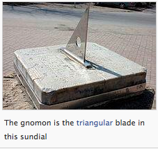
Anaximander (610-546 BCE, a pre-Socratic Greek philosopher who lived in Miletus, a city of Ionia) is credited with introducing this Babylonian instrument to the Greeks. The gnomon (γνώμων, literally “one that knows or examines”) is the part of a sundial that casts the shadow and is used for a variety of purposes in mathematics and other fields. In the fourth century BCE, Pytheas of Massalia gave much attention to the measurement of latitude by way of the gnomon (3). The “bisection of the angle between two shadows of equal length was sufficient to establish a precise meridian line, and so to divide the compass or horizon circle” (4). With the use of the gnomon, and the knowledge that the shape of the earth is spherical and “that the Sun’s annual path across the concave” is at an inclination, the ancients could then compare latitudes of places by lengths of the midday shadows of the gnomon (5).
Link to map of Erastothenes here
Link to image of gnomon here
Sources
1. E.G.R. Taylor, The Haven-Finding Art: A History of Navigation from Odysseus to Captain Cook (London: Hollis & Carter, 1956), 10.
2. Charles H. Cotter, A History of Nautical Astronomy (Toronto: Hollis & Carter, 1968), 12.
3. Ibid., 19.
4. Taylor, Haven-Finding, 44.
5. Cotter, History, 128.


